BMEWS - 510 Full Days - J-Site
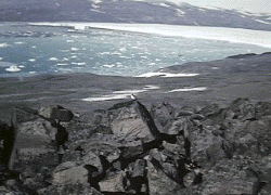
 Situated on a high bluff, several hundred
feet above and overlooking the head of Wolstenholm Fjord and about
three miles from the ice cap, J Site commanded a magnificent view
of the fjord! Entering the fjord from the edge of the ice cap
were three glaciers. During the summer we were treated on several
occasions to watch icebergs calve from the glaciers. Once the
fjord thawed, the water was a deep blue color. With the crystal
blue fjord dotted with white icebergs in the foreground and the
white glaciers in the background, the J Site location seemed an
appropriate place for a resort for those who have been everywhere.
Situated on a high bluff, several hundred
feet above and overlooking the head of Wolstenholm Fjord and about
three miles from the ice cap, J Site commanded a magnificent view
of the fjord! Entering the fjord from the edge of the ice cap
were three glaciers. During the summer we were treated on several
occasions to watch icebergs calve from the glaciers. Once the
fjord thawed, the water was a deep blue color. With the crystal
blue fjord dotted with white icebergs in the foreground and the
white glaciers in the background, the J Site location seemed an
appropriate place for a resort for those who have been everywhere.
 Because of the very low humidity and crystal
clear air, it was impossible to accurately judge distance. Very
early in my tour someone asked me how far I thought it was from
J Site to the glacier across the fjord. I could tell it was quite
a way off and guessed "maybe five miles." It turned
out that the glacier was about seven miles away (recent Google Earth measurement)! When the weather
warmed up enough for us to be outside for extended periods, but
before the fjord thawed, we left J Site at the end of a shift
and attempted to walk to that glacier. We turned back long before
reaching it in order to get back to J Site for our next shift
with a new respect for the vastness that was Greenland.
Because of the very low humidity and crystal
clear air, it was impossible to accurately judge distance. Very
early in my tour someone asked me how far I thought it was from
J Site to the glacier across the fjord. I could tell it was quite
a way off and guessed "maybe five miles." It turned
out that the glacier was about seven miles away (recent Google Earth measurement)! When the weather
warmed up enough for us to be outside for extended periods, but
before the fjord thawed, we left J Site at the end of a shift
and attempted to walk to that glacier. We turned back long before
reaching it in order to get back to J Site for our next shift
with a new respect for the vastness that was Greenland.
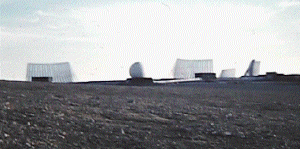
In apparent harmony with the rest of Greenland,
J Site itself was immense! The site, housing a single radar system,
was made up of nine buildings connected by an enclosed roadway,
which we called "the tunnel", stretching for over a
mile. There were four stationary detection radar antennae, each
about the size of a football field arranged in an arc, facing generally
north. In front of each antenna was a scanner building which housed
the "organ pipe scanner" which provided the radar energy
and scanning motion to the stationary antenna. Since the detection
radar antennae were too large to move, the organ pipe scanner
moved the beam with relation to the antenna. It got its name from
the arrangement of several dozen waveguides or pipes, which were
fed from a rotating waveguide switch. The pipes, each connected
to a feed horn, formed two horizontal rows, one above the other.
The beam from each antenna provided radar coverage of 40 degrees,
yielding a total of 160 degrees of radar detection over the pole.
The four fan-shaped beams of radar energy would provide a warning
of every missile firing that took place in the Soviet Union. The
job of BMEWS was to remove any surprise, assuring Soviet destruction
if they launched an attack.
Between each of the four scanner buildings,
about an eighth of a mile down the tunnel was a transmitter building.
Running through the tunnel were literally miles of waveguide,
connecting the scanners to the transmitters with several sources
of energy each. Hundreds of miles of inch-thick, multi-conductor
cable also ran down the tunnel in cable trays stretching between
the buildings carrying control, communication
and radar receiver information. My earliest impression of the
installation lay with the precision with which the cables were
placed. Each was laid perfectly straight in the cable tray, never
crossing over or under another. Each was tied down at precise
intervals, with the knots in the cable ties all facing the same
direction. Where cables had to bend around corners, the radius
of the bends of all the cables in the tray were exactly the same.
A five-billion-dollar project (in 1960 dollars), the Air Force
demanded, and got, perfection. At the end of the tunnel were the
site mess hall, receiving docks, and a machine shop. Just beyond
the mess hall and shop was a power building which provided backup
electrical power in case of a main power failure. Providing transportation
between the buildings was a passenger trolley made up of a warehouse
tug and several warehouse trailers which had a bench seat built
down the middle and enclosed against the cold. It made scheduled
trips from one end of the tunnel to the other, stopping at each
building to pick up and discharge passengers and small cargo.
Not comfortable by any means, the trolley beat walking when it
was cold.
When we first arrived at Thule, the only
operational radar was the detection radar which went into service
in September, 1960. The stationary detection radar system looked
out over the North Pole for a first warning of missile attack,
providing launch and trajectory information to the Missile Impact
Prediction System (MIPS) computer. MIPS could provide a relatively
coarse level of prediction of the missile's target based upon
the detection radar returns. The detection radar delivered two
fan-shaped energy patterns, one above and at a higher angle than
the other. As a missile was launched, it would penetrate the lower
beam. Signals returned from the missile would carry "doppler"
information, which provided a measure of motion toward or away
from the J Site, as well as range and azimuth information. A few
moments later, the missile would penetrate the upper fan, providing
a somewhat finer measure of trajectory. The difference in range
between the first fan penetration and the second, combined with
the doppler information and azimuth from each penetration, would
provide sufficient information for the BMEWS MIPS computers to
determine whether a missile was a potential attack threat.
Under construction was the tracking radar
system which would be used to look at potential threats identified
by the MIPS and the detection radar data and fine tune the prediction
of the missile's probable target. The massive radome had just
been started on the roof of transmitter building three. Soon to
become a white sphere 110 feet in diameter at the equator, the
geodesic dome was being lifted into place, piece by piece, by
a crane which reached 150 feet into the sky and assembled by a
crew hanging in a work basket in another, equally large, crane.
The dome was constructed of a honeycomb material constructed of
paper and epoxy resin in a honeycomb about 6 inches thick. There
was a combination of several different shapes, pentagons, and
hexagons, which were bolted together to build the dome.
I delighted in watching the radome's progress as I arrived at
J Site each day.
The construction of the tracking radar's
antenna and mount was an engineering feat. The pedestal upon which
the tracker's moving antenna would be mounted was built of solid,
reinforced concrete in the shape of an hexagon eight feet on each
face. This pedestal, buried in the permafrost down to a shale
base about 30 feet below the surface of the ground, would extend
upward to the roof of the transmitter building three stories above.
In order to dissipate the heat of the curing concrete, which would
melt the permafrost and cause the shale bedrock to slip, a refrigeration
system was constructed around the underground portion of the pedestal.
The refrigeration ensured that the permafrost stayed frozen and
the antenna pedestal would remain stable. It always seemed to
me to be paradoxical that one needed to refrigerate the permafrost!
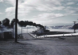 J Site power was normally supplied by oil
fired turbines aboard a ship at permanent anchor in the bay. About
85 megawatts would be required to provide full power to the radar
and auxiliary equipment, lights and computers. Heat generated
by the power ship kept the water in the ship's permanent mooring
thawed even at -40 degrees. Providing backup power were six incredibly
large diesel powered generators in the J Site power building.
Each generator could supply 12 megawatts. The engines were four
cylinder diesels of mammoth proportions; the cylinder bore measured
about 4 feet in diameter, and connecting rod bearing journals
were nearly 6 feet in diameter. Even with this much backup power,
the few times we needed it we had to detune the transmitters to
about 80 percent of the normal output power and turn off many
of the lights just to keep some capability. Happily, it was rare
that we needed the backup; the power ship was very reliable.
J Site power was normally supplied by oil
fired turbines aboard a ship at permanent anchor in the bay. About
85 megawatts would be required to provide full power to the radar
and auxiliary equipment, lights and computers. Heat generated
by the power ship kept the water in the ship's permanent mooring
thawed even at -40 degrees. Providing backup power were six incredibly
large diesel powered generators in the J Site power building.
Each generator could supply 12 megawatts. The engines were four
cylinder diesels of mammoth proportions; the cylinder bore measured
about 4 feet in diameter, and connecting rod bearing journals
were nearly 6 feet in diameter. Even with this much backup power,
the few times we needed it we had to detune the transmitters to
about 80 percent of the normal output power and turn off many
of the lights just to keep some capability. Happily, it was rare
that we needed the backup; the power ship was very reliable.
Table of Contents
Next
© Copyright 1996, Gene P. McManus, Baltimore, OH