Dick writes:
"Enclosed is a portion of an article from the Sept - Oct 1995 issue of Montana Magazine entitled `Opheim - A town set apart`, from the Small Towns section.
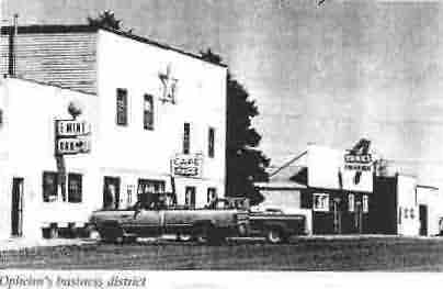
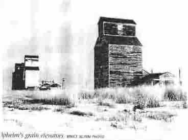
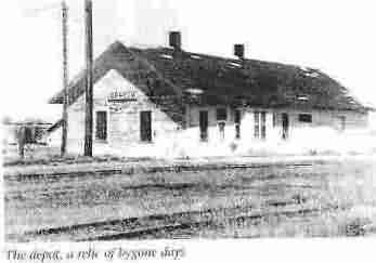
The photos marked as Opheim`s business district, Opheim`s grain elevators, and the depot, a relic of bygone days are pertinent because they were visual landmarks seen every day by those serving at the radar base and living in town, as were most married airmen under E-5 and the Tech Reps.
The current Homestead Cafe seen in the `business district` photo was known then as `The EZ Rest Hotel - Opheim`s Finest`. There were four apartments on the upper level of the building. I lived in the apartment on the upper left, where the two windows are located right next to the large star. All the apartments and individual rooms had shared bathrooms - two bathrooms for the four apartments and individual rooms - it got crowded on weekends when the combiners and ranchhands were in town! The state liquor store was situated in the hotel lobby - how covenient for me!
The green and red neon sign was located right outside the bedroom window, buzzing and snapping away all night long!
There were three of these type places to live: the EZ Rest, the Valley Hotel, and Dahl`s Apartments, which is the long green building shown in one of the other pictures of Opheim. We lived there as well, the best place in town to live. Several of those living off-base rented houses in the town. Three bars served the town, Tim`s Club Bar, The Mint Bar, and Turk`s Tavern. There were a couple of gas stations, a small machine shop run by retired Sgt. Stroh, a gun shop, Post Office, small bowling alley, one mercantile, a local airstrip, a consolidated K thru 12 School, and several churches.
The only paved roads were the highway leading into town from the south, and the road leading from the town to the base. All others were gravel, resulting in many broken windshields and burst gas tanks. One of the first thing a new troop did after arriving at Opheim was to install an engine heater for that 30 - below - zero - and colder weather, and cover the gas tank with rubber matting to prevent punctures from flying rocks as you drove 50 - 60 miles an hour down dirt and gravel roads.
The grain elevators and the train depot were seen when coming into town from Glasgow. The road to the base (Thorny Road) headed west from the town past the elevators and train depot.
When it was windy, tumbleweeds would occasionally roll down the base road and stack up against the fence lines where the road entered the town.
The townsfolk were genuinely fine people, generous and friendly, and willing to help any way they could. Definitely the salt of the earth, as most rural people are."
The establishment of the Opheim Radar Base four miles west of town brought new excitement and new life to the town in early 1952. The radar base brought in 135 U.S. Air Force personnel and 23 civilian workers. The town`s poplulation soared and businesses flourished. Crowds gathered every night at the town`s new bowling alley and at the three taverns along Main Street. The boom-town days came to an end in 1979 when the government closed the radar base. Families moved away, leaving a trail of boarded-up housese and vacant business buildings. The bowling alley moved to Columbia Falls. Opheim`s population dropped from over 500 to less than 150.
In the early 1990s, Scobey and Plentywood joined all of the other towns along the branchline in a valiant battle to keep the railroad in operation, but Burlington Northern rejected all of their appeals and closed the line in 1992, later removing the tracks and demolishing the bridges.
The prarie trails leading to Opheim eventuall became gravel roads, but they were still impassable for long periods of time because of snow or mud. Opheim`s 3,280 foot elevation is higher than most of the surrounding countryside, and it usually gets more snow and more severe storms than nearby areas. Probably every one of Opheim`s 145 residents can tell a harrowing tale of begin stranded in a blizzard, stuck in a snowdrivt, or mired in the mud.
Opheim`s impassable roads brought national publicity to the town during the winter of 1949-1950, when a heroic Great Northern Railway engineer and crew braved a fierce blizzard and huge showdrifts one winter night to make an unscheduled trip to Scobey with a critically ill Opheim girl and her elderly homesteader doctor. (The girl recovered.)
Roads were improved by little during the `50s, `60s, `70s and `80s, and portions were paved during those years. The establishment of the Glasgow Air Base in 1952 led to the paving of the first 16 miles of Highway 247 (now Highway 24) north of Glasgow. In 1966 Opheim celebrated the competion of that highway from Glasgow all the way to the Opheim Port of Entry at the international border. Opheim`s main street was paved that year, and is still the only paved street in town. It remains a popular spot for street dances and community celebrations.
Norris Opheim died last fall at the age of 95, but the town that bears his name remains very much alive.