U.S. Navy Radar Picket Ships
1955 - 1965
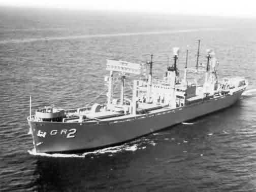
USS Lookout - AGR-2
 |
 |
 |
 |
USS Lookout - AGR-2
|
|
|
|
Source: http://www.yagrs.org/
In the 1950's the US Navy was assigned the task of extending the DEW Line seaward. To accomplish this task the Navy looked for a ship that would offer a stable platform for all of the electronics and radar that would be needed to be carried aboard ship.
The type of ship decided on was World War II Liberty Ships, the best type would be the box-aircraft type (Z-ECS-S-C5).
In 1954 the conversion of these ships started. This new class of ship would be called the Guardian Class and they would be classified as YAGR. At the end of these conversions in 1959 there would be sixteen (16) of these ships - eight (8) homeported at Treasure Island, CA, and eight (8) at Davisville, RI.
After these conversions the ships did not change their outward appearance much, except for their distinct radars - one of which was a special SPS-17A antenna designed specifically for these ships. However the interior was something else. The most powerful and modern air and surface radars and communications equipment were installed; as not only would these ships extend radar coverage seaward, they would track and direct aircraft, report weather conditions and numerous other task.
Click above for article from the April 2002 edition of Sea Classics magazine
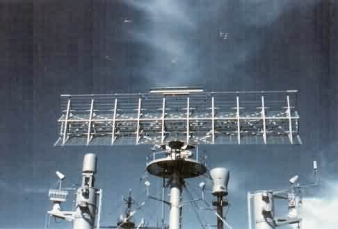 AN/SPS-17A Search Radar |
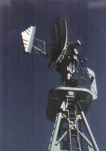 AN/SPS-8 Height-Finder Radar |
Click the link below for photos & notes on individual ships.
- AGR-1 USS Guardian
- AGR-2 USS Lookout
- AGR-3 USS Skywatcher
- AGR-4 USS Searcher
- AGR-5 USS Scanner
- AGR-6 USS Locator
- AGR-7 USS Picket
- AGR-8 USS Interceptor
- AGR-9 USS Investigator
- AGR-10 USS Outpost
- AGR-11 USS Protector
- AGR-12 USS Vigil
- AGR-13 USS Interdictor
- AGR-14 USS Interpreter
- AGR-15 USS Interrupter (renamed Tracer)
- AGR-16 USS Watchman